
Australia’s Marine Protection Gap
Australia has established one of the world's largest marine park systems, covering approximately 52% of the national Exclusive Economic Zone (EEZ), including the EEZ associated with mainland Australia and its offshore Territories. However, aggregate protection statistics alone provide an incomplete picture of conservation effectiveness because they do not account for differences in protection level, geographic distribution, or ecological representation.
Approximately 25% of Commonwealth waters is currently managed within highly protected no-take zones. However, protection is not distributed evenly across Australia's marine estate. Much of Australia's highly protected area occurs in remote offshore and territorial waters, particularly around Australia's external territories and subantarctic regions. In contrast, only approximately 9.6% of Commonwealth waters surrounding mainland Australia are managed within highly protected no-take zones.
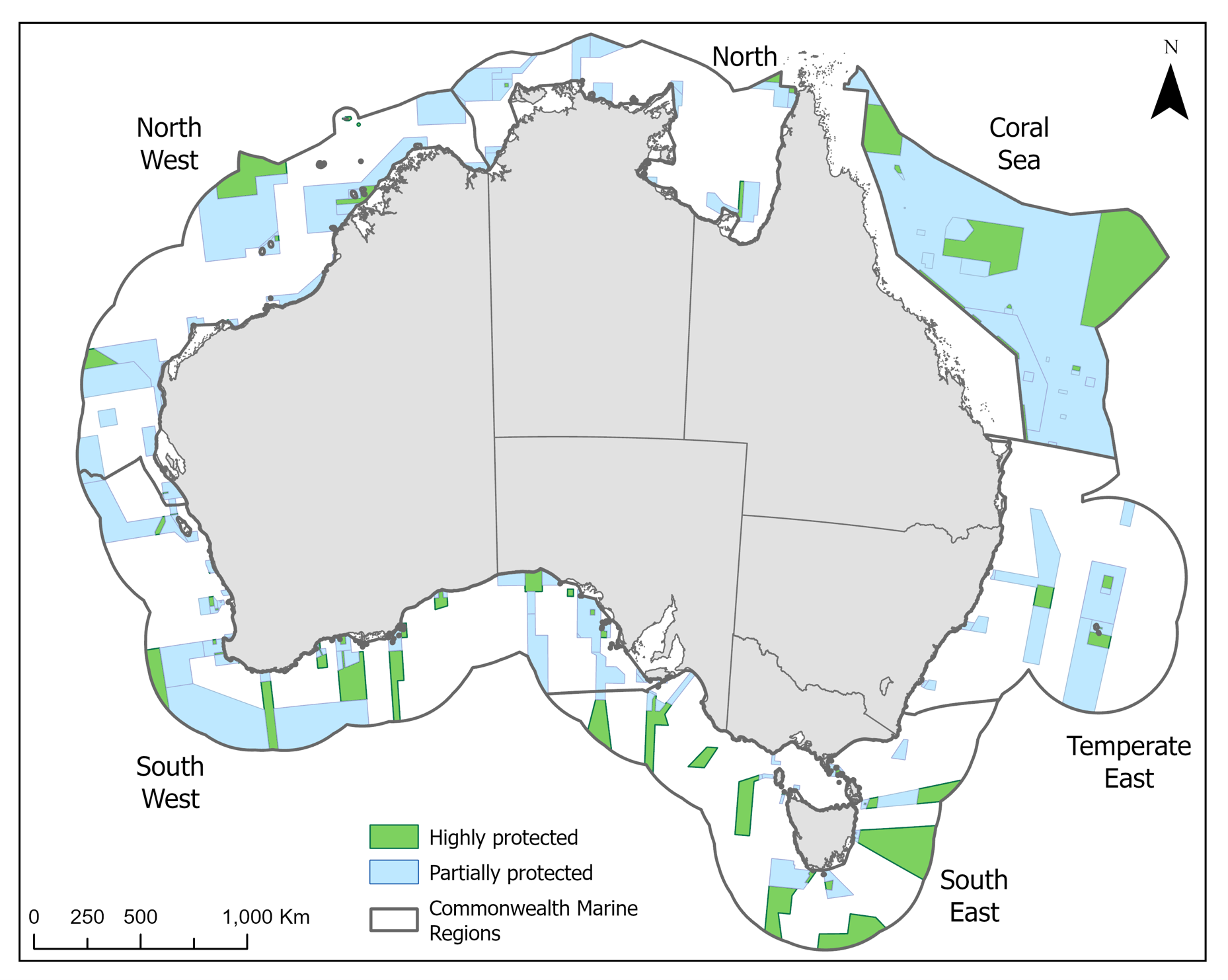
Figure 1: Mainland Australia's Commonwealth Marine Parks by Network
The disparity between mainland and territorial waters is evident in current protection statistics (Table 1). Highly protected zones comprise approximately 99% of the Indian Ocean Territories Marine Parks and 73% of the Subantarctic Marine Parks. By contrast, highly protected zones comprise only 1% of the North Marine Parks Network, 2% of the Temperate East Network, 5% of the North-west Network and 7% of the South-west Network. The Coral Sea Marine Park contains approximately 24% highly protected area and is therefore responsible for much of the highly protected area within waters surrounding mainland Australia. The recently reviewed South-east Network has now highly protected 16% of its mainland area. In the latter two cases, despite the increases in protection, highly protected zones are concentrated in residual areas rather than distributed according to CAR principles. Consequently, national protection statistics are strongly influenced by large and remote territorial marine parks, while protection levels remain comparatively low and non-representative across many marine regions surrounding mainland Australia.
The distinction between total marine park coverage and highly protected area is equally important. While between 20% and 33% of waters within the North, North-west, Temperate East and South-west marine park networks fall within marine parks, only a small proportion of these areas are managed as highly protected no-take zones. As a result, statistics describing overall marine park coverage can create the impression of stronger protection than is delivered through highly protected zoning alone.
Australia’s current pattern of protection is consistent with residual reservation, whereby protected areas are preferentially established where conflict with extractive activities is relatively low rather than where conservation need is greatest (Devillers et al. 2020). Consequently, many productive shelf and slope ecosystems remain under-represented within highly protected zones despite supporting substantial biodiversity, fisheries productivity and ecological connectivity.
The resulting pattern is one in which national protection targets have largely been achieved through extensive protection in remote offshore and territorial waters, while comparatively low levels of highly protected area remain across many marine regions surrounding mainland Australia. This disparity highlights the difference between achieving area-based protection targets and achieving a representative network of highly protected marine parks.
References
Devillers, R., Pressey, R.L., Grech, A., Kittinger, J.N., Edgar, G.J., Ward, T. & Watson, R. (2020). Residual marine protected areas five years on: Are we still favouring ease of establishment over need for protection? Aquatic Conservation: Marine and Freshwater Ecosystems, 30, 1751–1754.
Table 1: Area of each bioregion and the percentage in highly protected (%HP; IUCN Ia and II) and within Commonwealth Marine Parks, independent of protection level (%MP; IUCN Ia, II, IV and VI). Values are derived from the individual management plans for each region¹, and exclude state waters.